In West Texas, abandoned well sinks land, sucks tax dollars
/https://static.texastribune.org/media/files/0dfbb8b6fc4e202cd55e3aa36295ad4d/.BellusPhoto.com_FtStockton_Imperial-0001.jpg)
PECOS COUNTY — The rusty pipe poking up from desert scrubland just south of Imperial would be easy to miss if you didn't know it was there. But the once-forgotten water well — a reminder of ranch life here decades ago — has developed an almost magical power: No matter how many taxpayer dollars the state throws into it, it threatens to suck up more.
Little by little, the long-abandoned well has dramatically altered the surrounding landscape. This land used to be flat. Now, it’s fissured, it's sinking — and it has cost taxpayers more than a million dollars and counting to repeatedly repair a two-lane road near the well. If the state has to re-route the road, the cost could rise to $15 million.
All because of a pesky hole in the ground.
“On both sides of the highway, you got big cracks,” Paul Weatherby, manager of the Middle Pecos Groundwater Conservation District, said in June as he pointed out odd ripples along Farm-to-Market Road 1053. “See how deep that ditch is right now?”
In either 1950 or 1951 — the records aren’t clear — somebody bore a well 2,800 feet into the West Texas earth. No one’s quite sure who did the drilling, but state records say that G.C. Holladay last owned the well. A 2010 obituary describes a G.C. Holladay Jr. — apparently the same man — as a farmer, army veteran and “avid outdoorsman” who lived for 60 years in Imperial before dying at 83. Two phone listings for his wife were disconnected.
Weatherby and Ty Edwards, the district’s assistant general manager, believe the Holladay hole was among dozens that oilmen drilled in this corner of the Permian Basin in the early-to-mid 1900s, hunting for black gold.
These gushed something else.
“They hit that damn water, and they just left,” Edwards said.
Farmers and ranchers like Holladay ultimately tapped these wells for irrigation and drilled others of their own. But when the farmland stopped producing decades ago, they walked away.
For years, the wells sat unplugged and unnoticed. But Mother Nature and geology can do strange things to these spaces. Cement casing and steel piping crack and corrode over time, and water can rise and migrate through the cracks.

Around the late 1980s, some of the corroded wells around Imperial (population 278) started spewing smelly, brackish San Andres aquifer water that had mixed with salts and other minerals on its way to the surface.
Over several years, the Holladay hole swamped the surrounding land, including a piece of FM 1053, a two-lane road that stretches nearly 60 miles across parts of Pecos, Crane and Ector counties. Beginning around 2004, the area began sinking as the water percolated back underground and ate away at underground salt formations.
Had its waters not flooded the road, the Holladay hole might be just another forgotten West Texas well that no one is willing to pay to plug. The Texas Railroad Commission, the state’s petroleum regulator, is responsible for plugging thousands of abandoned oil wells — a growing list that’s spurring groundwater pollution fears — but no state agency is charged with sealing water wells.
Because this well threatened a state-maintained road, the Texas Department of Transportation stepped forward to plug it. In late 2008, the agency found a contractor who agreed to do it for about $125,000, said Mark Cross, an agency spokesman. The cost soared to $315,000 by the time the work was finished three months later (a local water district and development council chipped in a small amount for the bill).
But by all accounts, the contractor botched the job. It plugged the well only at the top rather than cementing all the way down. This stopped the flow above ground but allowed the brackish water to continue mixing and mingling below.
Things got worse quickly. The well and the surrounding ground has sunk nearly 40 feet since the plugging. The land along FM 1053 is dropping three-fourths of an inch every month, and the road is shifting west toward the well, Cross said. The depression caused by the well now measures 1,400 feet across.
All of this has meant pricey roadwork.
Over the past decade, the transportation agency has twice raised the road, at a cost of $500,000. And in December, it shelled out $500,000 more to fix a mile-long stretch near the well. Now, the agency is considering rerouting the road to avoid the sinking ground altogether. That could cost between $10 million and $15 million — maybe more, and it wouldn’t be easy.
“The are many obstacles to avoid, Cross said: “Oil and gas wells, multiple other artesian wells, and other utilities.”
But will the land here ever stop sinking? That’s what Gil Van Deventer, an Odessa-based hydrologist who has looked at the phenomenon from the surface, is wondering.

About about an hour’s drive north, the Wink Sinks — chasms of fascination and fear between the towns of Kermit and Wink — gulped huge chunks of land atop the Hendrick oilfield. Wink Sink No. 1 — more than a football field across and 100 feet deep after it collapsed — turned 36 years old last June. Its more massive cousin to the south, Wink Sink No.2, swallowed a water well, pipelines and surrounding desert back in 2002.
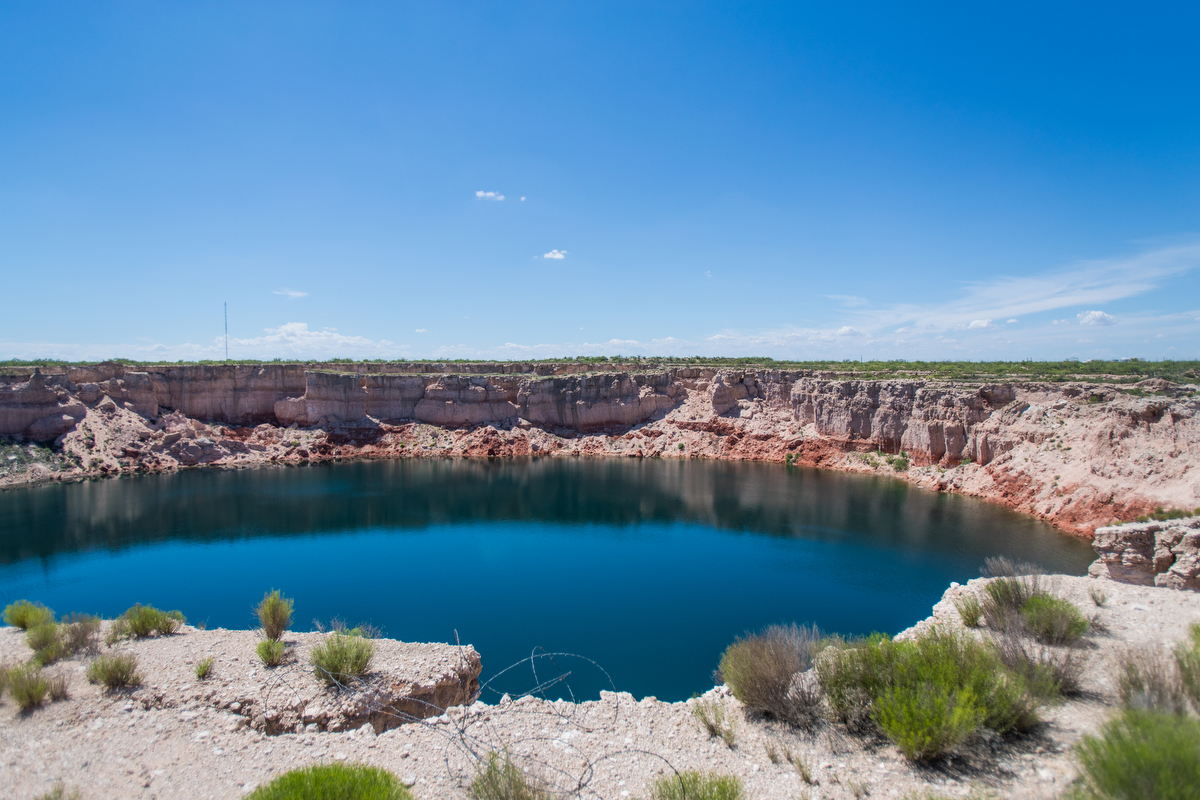
Van Deventer sees similar conditions forming at the Holladay hole and a nearby abandoned well that has spewed a putrid body of water dubbed Boehmer Lake.
“I think there’s going to be more sinkholes in our future,” he said.
Cross said his agency’s experts don’t believe this area will see a "catastrophic" failure like near Wink, “but they have no idea how deep this subsidence will continue to go.”
Or how much it will cost.
Read more Texas Tribune coverage of these topics:
- Texas is among several states grappling with a surge of abandoned drilling sites and dwindling funds to clean them up.
- A recent study has thrust the Wink Sinks — two breathtaking sinkholes in Winkler County which have long been objects of fear and fascination — into the national spotlight.
- Texas regulators have allowed energy companies in recent years to inject toxic materials into at least a “handful” of underground sources of drinking water, records show.
Information about the authors
/https://static.texastribune.org/media/profiles/Jim_1.jpg)
Learn about The Texas Tribune’s policies, including our partnership with The Trust Project to increase transparency in news.